© 2014-

INTERNATIONAL WATERS
Because of the geographical nature of New Zealand, isolated in the Pacific Ocean with no near neighbour which could be used as a tendering or supply base, Radio Hauraki was much more difficult to operate than the offshore stations in Europe.
Consequentially Radio Hauraki had to resolve the problem of identifying an anchorage position for the station's ship which would enable its signal to reach the target area of Auckland.
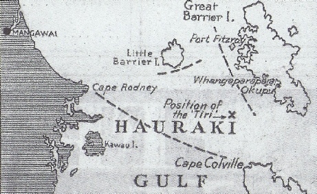
Auckland lies at the head of the Hauraki Gulf, which forms a large bay at the top of New Zealand's North Island. Under international maritime law all waters within a line drawn from one headland to the other across the mouth of a bay are declared to lie inside territorial waters. At first it was thought that the radio ship would have to anchor three miles outside this line, effectively 50 miles out to sea, which would have been too dangerous in the exposed seas beyond Great Barrier Island.
However, a closer examination of maps revealed that there existed a small triangle of sea in the Hauraki Gulf between Little Barrier Island, Great Barrier Island and the Coromandel Peninsular which was, technically, international waters .

Do you have any other memorabilia about Radio Hauraki which we could add to this Special Exhibition?
If you do, and you are willing to allow the Museum to use it, please contact
resources@offshoreradiomuseum.co.uk
We look forward to hearing from you


This map.published in the New Zealand Herald the day after Radio Hauraki was launched indicates (by dotted lines) the triangle of international waters which the offshore station had identified in the Hauraki Gulf


Ground
Back to


Click here to visit the New Zealand Gallery and the full story of Radio Hauraki


