© 2014-

Taking to Water (1)
The effect of tightly controlled national restrictions, as well as new post-
The framework of international law which allowed such a situation is quite complicated, but was the only option left to pursue. The concepts of 'national' and 'international' waters as well as the extent of territorial jurisdiction generally are laid down by international treaties and accepted by virtually every sovereign state throughout the world. These definitions, and rules for their application, are embodied in two International Conventions agreed at Geneva in 1958.
The extent of territorial jurisdiction beyond a state's own land mass is governed principally by the first treaty -
This Convention set down the principle that the sovereignty of a state can extend beyond its own land mass and defined specific areas of water including 'internal or national waters', 'territorial sea' and 'bays', all of which fall within the jurisdiction of the state. The Convention also went on to prescribe rules for determining the starting point from which territorial limits should be measured.
Internal (or National) Waters and Territorial Sea
Internal (or national) waters are those areas, including parts of the sea, which come under the full sovereignty of the territorial state. Such areas include inland waters (rivers, lakes, ports, harbours, anchorages, bays, gulfs and estuaries), areas of sea separated by islands and all waters to the landward side of baselines used as the starting point to measure the territorial sea.
The relevant state has jurisdiction over foreign merchant ships while they are in or travelling through these internal waters. Persons who have committed crimes on board foreign ships in internal waters may be arrested by the territorial state, which has jurisdiction concurrent with that of the vessel's flag state.
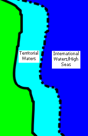
The territoria l sea is defined by the 1958 Convention as "the area to which the sovereignty of a state extends beyond its land territory and internal waters to include a belt of sea adjacent to the coast." This sovereignty also extends to airspace above the territorial sea as well as to its bed and subsoil.
At the time the Convention was agreed and for many years afterwards, (including the majority of the time offshore radio stations operated) the territorial sea was measured as a distance of three nautical miles from the coast. However, this distance was not itself fixed by international agreement. Indeed attempts to define a maximum breadth for territorial waters had failed at the Hague Codification Conference in 1930 and again at the United Nations Geneva Conference in 1958. Agreement was, however, reached with the 1982 United Nations Convention on the Law of the Sea (UNCLOS) which gave states the right to extend their territorial claim to 12 miles (which had obvious and serious significance for the few remaining offshore stations operating at that time).
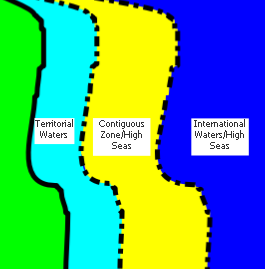
The 1958 Convention did, however, fix an outer territorial limit of what was known as the 'contiguous zone'. This was determined as twelve miles from the baseline (usually a low water mark) from which territorial sea is measured and was the maximum distance to which any state could reasonably expect to extend its territorial claim.
In practice, from the 1958 agreement most coastal states confined their territorial limits to three nautical miles and it was this relatively short claim that offshore radio stations were able to exploit so successfully for many years. Potential audiences were within easy reach of powerful (and sometimes not so powerful) transmitters and transporting regular supplies and personnel from land to the ships or other structures was relatively practical to achieve.
High Seas or International Waters
The second Convention agreed at Geneva on 29th April 1958 dealt with the 'High Seas' -
This Convention basically stated that the high seas are open to all nations so that no one state may subject any part of them to its sovereignty. Freedom of the high seas is defined by the Convention as:-
- freedom of navigation
- freedom of fishing
- freedom to lay submarine cables and pipelines , and
- freedom to fly in the airspace above such waters
These freedoms are available to all states, coastal and non-
The general and most basic freedom of the high seas, as defined by the Convention, is the freedom of navigation. No state may interfere with ships of other states or exercise jurisdiction over them in times of peace, except inside the contiguous zone (i.e. the additional, usually nine miles, adjacent to the (three mile) territorial sea.) Even then inside this Contiguous Zone such interference can only be exercised to prevent infringement of a state's customs, fiscal, immigration or sanitary regulations or to pursue (under the doctrine of 'hot pursuit') infringements of those regulations which have already been committed inside its territory or territorial waters
If a merchant ship is boarded under the conditions outlined above and it transpires that the suspect ship has not actually committed any violation justifying such action then the owners of that ship must be compensated for any loss or damage which may have been sustained.
A warship does, however, have the right to verify the ship's right to fly its flag -


Ground
Floor
Back to


State Monopolies and International Agreements


Back to Gallery index

Taking to Water (2)
